Tuesday night… cloudy with showers and thunderstorms beginning after 9 PM, mixing with snow around 3 AM, becoming all snow after 5 AM. Low of 28 degrees. Northeast winds 15-25 mph, gusting to 35 mph late.
Wednesday…mostly cloudy with snow ending in the morning. Total snow accumulations of 1-3″ possible. High of 30 degrees, falling during the afternoon. Northwest winds 20-25 mph, gusting to near 40 mph during the afternoon.
Wednesday night… cold with cloudy skies slowly becoming clear overnight. Low of 11 degrees.
Thursday… mostly sunny with a high temperature of 39 degrees.
Thursday night… clear skies with a low of 30 degrees.
Friday… mostly sunny with a high of 54 degrees.
Friday night… partly cloudy skies with a low of 31 degrees.
Saturday… partly cloudy with a high of 50 degrees.
Saturday night… partly cloudy with a low of 29 degrees.
Sunday… partly cloudy with a high of 45 degrees.
Discussion: Temperatures have already begun falling in Champaign-Urbana with the passage of a cold front, and precipitation will begin moving into the area within the next hour or two in the form of showers and thunderstorms, changing to snow by morning.
After seeing high temperatures in the middle to upper 60s in the region, we have fallen into the lower 50s with the passage of a cold front around the dinner hour. Showers and thunderstorms are beginning to develop to our southwest near St. Louis, and those should begin moving into our area between 9 and 10 PM. Some embedded thunderstorms are possible, and rain may at times be heavy. With already saturated ground from previous snow melting, we could see standing water fairly quickly overnight.
Moderate to heavy rain should begin mixing with some large snowflakes around 3 AM, before slowly changing to all snow by 4 or 5 AM. At this time, the heaviest precipitation should already be exiting the area. A brief period of heavy wet snow is possible between 5-7 AM, but snow should begin tapering off shortly after, ending by 9 AM. Winds will continue to increase to around 20-25 mph, perhaps gusting to near 40 mph, so blowing snow may be an issue in rural areas.
I am seeing many forecasts calling for between 3″ and 7″ of total snowfall accumulation in Champaign, but I just do not see us seeing totals that high. As stated earlier, the heaviest precipitation should be leaving our area before we transition to all snow, and the heavy wet snow that follows around sunrise will have trouble accumulating quickly. I just don’t think we will see 3-7″ stack up in the 3-4 hour period that we see all snow in C-U. I have been wrong, and will be wrong again many times when forecasting snow totals, and tonight may be one of them, but I am having a hard time budging from my 1-3″ total snow accumulation forecast for Champaign tonight and tomorrow morning.
Snow will quickly exit around 9 AM, with skies slowly clearing toward sunset. Cold air will follow, with temperatures slowly falling through the day on gusty northwest winds. After two days in the 60s, this will probably be quite a shock to our systems.
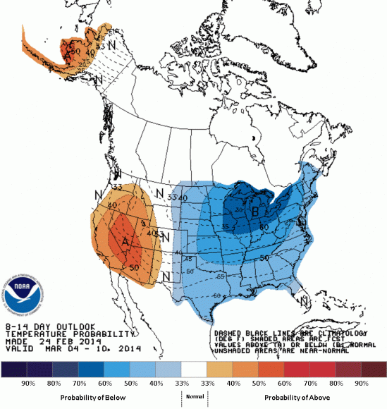
Clear skies and calming winds will allow temperatures to plummet on Wednesday night, falling into the teens with ease. With less snowfall than computer models are forecasting, I do think we’ll have trouble seeing single digit low temperatures, and will likely bottom out right above 10 degrees.
The good news is, we will warm back up in the days that follow, returning to the 50s by Friday afternoon and quickly melting any snow that does fall tonight.