The rest of the bust… Oct 4th cont’d

For a pretty lame day, I did take quite a few pictures on October 4th over in my favorite state. It looks like I will end my first tornado-less calendar year since 2005 so I may as well give the busts as much love as I can. 

The face of a storm chaser who doesn’t like a single thing he is seeing on his phone.

Image

Colin shooting the storm that would be our only hope during daylight hours from our Red Oak, Iowa gas station parking lot. 


Image


Image

In typical Iowa fashion, a river valley prevented us from shooting the storm right as the sun hit the horizon. The storm quickly died at this point. 

Image

Image

Oh, did you want these storms before dark? A new area quickly developed to our south, right over Red Oak, Iowa where we had sat all afternoon, and quickly went Tornado Warned. 

Image

Lightning in a wind farm near Alta, as the storms to our southwest quickly died as they approached. 

Image

Image

Tornado drought day 500+

The tornado drought has surpassed 500 days. I returned to the road on Friday with the motivational help of my chase partner Colin Davis. The setup looked potent over Nebraska and Iowa, and after a fruitless spring my days are limited as far as avoiding a tornadoless 2013 are running out. When in a sky rut such as this, each potential outing kind of has that “what’s the point” feeling beforehand, but a warm and humid Thursday with cauliflower in the sky helped light the fire inside, and after browsing the evening weather data I sent several texts to Colin saying that the chase was certainly on. We planned to leave his place in Canton, IL at 7 am, which meant I’d be leaving Champaign around 5. After a slightly earlier than planned 3 am wake up, I threw all of my camera gear in the car and grabbed a cup of coffee and hit the road. There really is no better feeling than that of driving down the highway with the windows down, letting in the moist morning air while the first hints of light start to peak over the eastern horizon. The day has yet to begin for most people, but already my head is swimming with visions of how it will play out. 

I rolled into Colin’s driveway around 7:30 and made the switch over to his vehicle and we hit the road. Spirits were high as I poured over the morning data. The obvious target was eastern Nebraska, but I always seem to get the smart ass idea that I should go for the underdog target. I had earlier suspicions that the warm front may not surge northward as quickly as forecast by some of the computer models due to early morning convection in the region, and that storms forming further north may be grungy and riddled with low visibility. Based on that hunch I was really liking a southwest Iowa target. I thought that given enough insolation during the afternoon, thunderstorms would redevelop near the Iowa/Nebraska border just south of Omaha and potentially interact with the residual outflow boundary left in the area by morning thunderstorms. We grabbed lunch and a new tripod for my forgetful self in Des Moines and then made the call to head southwest and pass up the Nebraska/nw Iowa target that most were sitting in, and drifted toward Creston, IA. 

Driving through Creston it was obvious enough to me that the system had slowed some, and that we may as well continue west a little further and park it in Red Oak, Iowa. We found a gas station with a large parking lot and a view of the western horizon and decided to wait there. 

So we waited. 

And waited. 

And waited. 

After a couple hours of waiting and several trips into the gas station for food and drinks, sunset was now only half an hour away. Our friends were intercepting tornadoes in Nebraska, and there was nary a cloud to be seen over our heads. It was subsidence city. Morning thunderstorms can leave outflow boundaries that later enhance thunderstorm rotation inducing tornado development, but that is conditional on an actual thunderstorm developing in the first place. These same outflow boundary producing thunderstorms can also leave in their wake a region of sinking air that acts to suppress any convective development. 

An isolated thunderstorm had developed in northeast Kansas and was drifting our way, but it was mostly ignored as it appeared to be behind the boundary and in a region of weaker low level shear so the tornado threat was not really present. However, around sunset this appeared to be the only play. The storm was coming into view, and mammatus were starting to overspread the sky. It was the only storm in sight, and we were seven hours away from home, so it was this or nothing. 

We jumped onto Highway 69 north and paralleled the storm for about half an hour before the sun finally hit the horizon and the storm collapsed on itself. In true ‘slap in the face’ Iowa fashion, a river valley prevented us from finding a spot to photograph the storm at its peak visual appearance as the sun hit the horizon casting a red glow on the underbelly of the storm. 

As we made our way toward home, other storms came and went, and excluding a brief stop for lightning photos we chose to ignore most of the after dark action. 

Busting is hard to stomach, but it is a little bit easier when the storm system as a whole fails to produce. But making the wrong call, when the more obvious target produces tornadoes and photogenic storms and most of your friends and colleagues have a successful evening while you catch a suntan in an Iowa truck stop parking lot a long way from home is pretty hard to take. 

Sometimes I look back at the successes of past years and wonder if I have lost the knack, but I hope that just as the highs come and go, this sky rut too shall pass. It does seem that every sky I touch turns to mush at this point, but I’ll keep at it, and the hopefully the sky drama will follow.

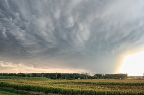
Mammatus filled sky on the west side of Red Oak, Iowa before we made our play on the storm, which almost immediately died. 

 Image


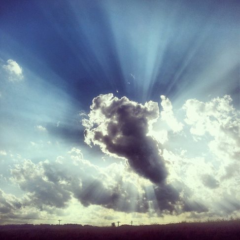
Busting can be photogenic at times… here is a cell phone shot of crepuscular rays around a failing cumulus cloud. We saw a lot of this as the evening progressed.


Image


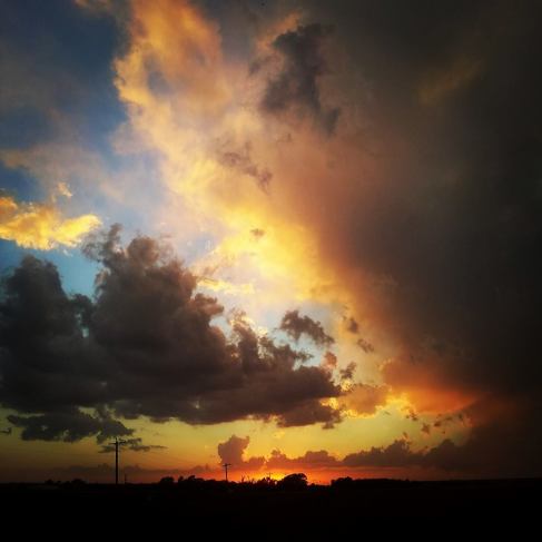
After the sun hit the horizon and our storm fizzled out completely. 


Image


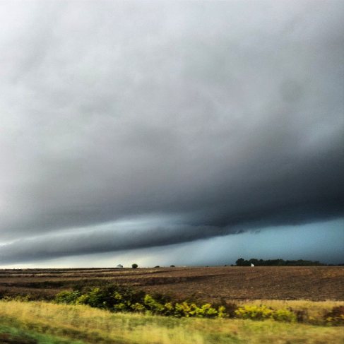
The best looking storm of the day was actually before we were ever in chase mode. Elevated thunderstorms went severe around the Des Moines area shortly after lunch, but we drove by as we continued toward the afternoon target area of Red Oak. 


Image

Tomatoes at 50mm

With every day I tack on another day to the longest tornado drought I have put myself through since getting a drivers license at age 16. Not since I was legally allowed to drive myself up to thunderstorms have I gone this long without spending the day with a tornado (473 days, now). So here are some pictures of plants.

I added the Canon f1.8 50mm prime lens to my bag on Wednesday on a Craigslist find and was anxious to test it out during the evening. The weather was miserable, with gloomy skies and a constant fine mist soaking everything through the day. I wasn’t going to drag someone out to pose in front of the new lens so I played tomato paparazzi.

ImageImage

Dwarfed by these tomato plants I have a habanero plant that has several large green peppers that I am impatiently trying to coarse into ripening. I am not entirely decided on what I am going to actually make with them once they do turn orange, but I’m sure I’ll regret eating it shortly after.

Top 15 from 2012

Every winter I typically go through and pick out 10 or 15 favorite images from the year. They might not be the 15 best photos that I snapped, but for whatever reason there may be these were the 15 photos that I’m the most emotionally attached to from 2012.

Really a pretty lame line of thunderstorms that was only photogenic for maybe five minutes in Lee County, Illinois in September.

Really a pretty lame line of thunderstorms that was only photogenic for maybe five minutes in Lee County, Illinois in September.

Star trails back at my favorite spot at home (same location as the golden wheat field).

Star trails back at my favorite spot at home (same location as the golden wheat field).

Lightning strikes from an erupting line of thunderstorms over Champaign, IL just after sunset on May 28 2012.

Lightning strikes from an erupting line of thunderstorms over Champaign, IL just after sunset on May 28 2012.

About as Illinois as it gets. I am in love with this spot in rural Champaign County because of the golden wheat field and the amazing view to the west and south. I was probably at this very spot 10-12 times this summer.

About as Illinois as it gets. I am in love with this spot in rural Champaign County because of the golden wheat field and the amazing view to the west and south. I was probably at this very spot 10-12 times this summer.

Really just because of the colors. High based convection over northern Illinois on May 15 2012.

Really just because of the colors. High based convection over northern Illinois on May 15 2012.

Vibrant double rainbow over northern Illinois on May 15 2012.

Vibrant double rainbow over northern Illinois on May 15 2012.

Timken, Kansas storm wraps up into a liberty bell shaped updraft during the April 14 2012 tornado outbreak.

Timken, Kansas storm wraps up into a liberty bell shaped updraft during the April 14 2012 tornado outbreak.

Went out to my favorite old abandoned house in Champaign County with my friend Jenn as I tried messing around with portraits shots early in the spring.

Went out to my favorite old abandoned house in Champaign County with my friend Jenn as I tried messing around with portraits shots early in the spring.

Violent EF4 tornado near Langley, Kansas

Violent EF4 tornado near Langley, Kansas

Rope tornado near Timken, Kansas early on during the April 14 2012 tornado outbreak.

Rope tornado near Timken, Kansas early on during the April 14 2012 tornado outbreak.

Lightning and the wind farm, hard to beat for me.

Lightning and the wind farm, hard to beat for me.

Been a pretty lame solar maximum thus far, but I caught a low green band of aurora and an iridium flare over northern Illinois early in the spring.

Been a pretty lame solar maximum thus far, but I caught a low green band of aurora and an iridium flare over northern Illinois early in the spring.

Star trails over my favorite place in the world, the family lakehouse in Wisconsin.

Star trails over my favorite place in the world, the family lakehouse in Wisconsin.

My friend Melanie and I pounded some red bull and played around in some golden autumn fields in October.

My friend Melanie and I pounded some red bull and played around in some golden autumn fields in October.

Lightning illuminated storm near Philo, IL on May 28 2012. This was just an impromptu stop on my way home from work on a summer evening.

Lightning illuminated storm near Philo, IL on May 28 2012. This was just an impromptu stop on my way home from work on a summer evening.